
QUATERNARY GLACIATION
Quaternary glaciation, also known as the Pleistocene glaciation, the current ice age or simply the ice age, refers to the period of the last few million years (2.58 Ma to present) in which permanent ice sheets were established in Antarctica and perhaps Greenland, and fluctuating ice sheets have occurred elsewhere (for example, the Laurentide ice sheet). The major effects of the ice age were erosion and deposition of material over large parts of the continents, modification of river systems, creation of millions of lakes, changes in sea level, development of pluvial lakes far from the ice margins, isostatic adjustment of the crust, and abnormal winds. The ice sheets themselves, by raising the albedo, effected a major feedback on climate cooling.
During the Quaternary Period, the total volume of land ice,
sea level, and global temperature has fluctuated initially on 41,000- and more
recently on 100,000- year time scales, as evidenced most clearly by ice cores
for the past 800,000 years and marine sediment cores for the earlier
period. There have been approximately 80
glacial cycles over this time. All of
this time is referred to as an ice age because at least one permanent large ice
sheet "
Over the last century, extensive field observations have
provided evidence that continental glaciers covered large parts of Europe,
North America, and
Causes
- Astronomical
cycles
- Atmospheric
composition
- Plate
tectonics
- Ocean
currents
Effects
Lakes: The Quaternary glaciation created more lakes
than all other geologic processes combined.
The reason is that a continental glacier completely disrupts the
preglacial drainage system. The surface
over which the glacier moved was scoured and eroded by the ice, leaving myriad
closed, undrained depressions in the bedrock.
These depressions filled with water and became lakes. Very large lakes
were created along the glacial margins.
The ice on both North America and
Pluvial lakes: The climatic conditions that cause glaciation had an indirect effect on arid and semiarid regions far removed from the large ice sheets. The increased precipitation that fed the glaciers also increased the runoff of major rivers and intermittent streams, resulting in the growth and development of large pluvial lakes. Most pluvial lakes developed in relatively arid regions where there typically was insufficient rain to establish a drainage system to the sea. Instead, stream runoff in those areas flowed into closed basins and formed playa lakes. With increased rainfall, the playa lakes enlarged and overflowed. Pluvial lakes were most extensive during glacial periods. During interglacial stages, when less precipitation, fell the pluvial lakes shrank to form small salts flats.
Isostatic adjustment
Major isostatic adjustments of the lithosphere during the
Quaternary glaciation were caused by the weight of the ice, which depressed the
continents. In
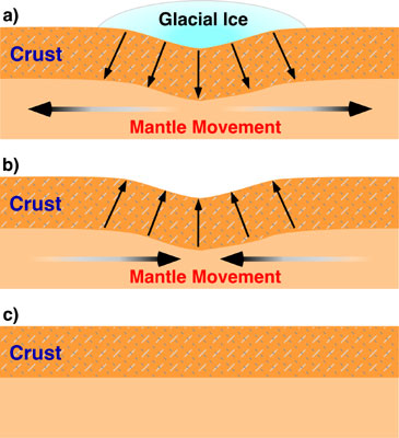
Studies have shown that the uplift has taken place in two
distinct stages. The initial uplift
following deglaciation was rapid (called "elastic”), and took place as the ice
was being unloaded. After this "elastic”
phase, uplift proceed by "slow viscous flow” so the rate decreased
exponentially after that. Today, typical
uplift rates are of the order of 1 cm per year or less. In northern
Winds
The presence of ice over so much of the continents greatly
modified patterns of atmospheric circulation.
Winds near the glacial margins were strong and persistent because of the
abundance of dense, cold air coming off the glacier fields. These winds picked up and transported large
quantities of loose, fine-grained sediment brought down by the glaciers. This dust accumulated as loess (wind-blown
silt), forming irregular blankets over much of the Missouri river valley,
central Europe, and northern
Sand dunes were much more widespread and active in many
areas during the early Quaternary period.
A good example is the Sand Hills region in